Delving into the rich human history of Martlesham Wilds

Delving into the rich human history of Martlesham Wilds

Jesse Walker

Join Margaret King, our Research Volunteer, in exploring the rich and varied history of people in the landscape of our Martlesham Wilds Nature Reserve.

When we look at Martlesham Wilds we see a landscape made of hills and woods, fields and meadows, streams and ever-changing shorelines. However looking instead at archaeological records, archives and maps, a different landscape emerges, one that is rich in human activity and stories. Martlesham Wilds has long been a 'lived-in' landscape.

The name Martlesham, or Merlesham, is probably from Old English, meaning a mooring place in a meadow bordering a creek. The Domesday Book tells us that there were 22 households, a church and a mill in 1086; all but one of the households had to pay service to the lord of the manor. The main livestock was sheep, with a few cattle, horses, pigs and beehives.

Well before that time, the Uffingas must have sailed past the Wilds on their way up the Deben to become the ruling dynasty of East Anglia. Later on, the longboats of the Viking raiders came up the marshy waterways. More than sixteen trackways, field systems and archeological finds from the time of the Anglo-Saxons and of the Romans have been recorded on Martlesham Wilds, thanks to aerial photographs and patient field-walking.

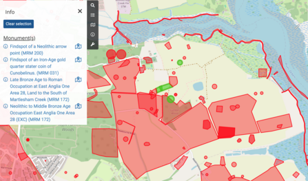
A map show sites of archaeological interest at Martlesham Wilds

Extract from Suffolk Heritage Explorer

© OpenStreetMap © 2025 Suffolk County Council Archaeological Services.

The light pink areas show land with trackways and field systems, the darker pink areas are locations of archaeological finds with four highlighted in green.

The light pink areas show land with trackways and field systems, the darker pink areas are locations of archaeological finds with four highlighted in green.

Even earlier in human history, coins from the late Iron Age, evidence of Bronze Age cremations, and a Neolithic arrow point have been found. Which begs the question - why here in Martlesham Wilds? Maybe it was the fresh water springs. And the sandy soils where natural woodland was not too dense, favoured for forest farming and the cultivation of crops by some of the earliest pastoral people. 

From Medieval to Tudor England

It is in the medieval period that we start to get much more of a picture about human life, and about the stewardship of the estate by the lord of the manor of Martlesham Hall. Sir John Verdun was lord of the manor in the 1320s. The manor house was probably on the same spot or close to where the Hall stands today. Verdun survived the Black Death of 1348 and with his third wife, Isabel, held four other manors in Suffolk and one in Norfolk. 

Some think that it was the Black Death that left the Hall and the Church isolated, but a more pragmatic explanation is that the villagers simply moved up to the turnpike when roads came into general use.

After Verdun's death, Edmund Noone married his widow and gained possession of the Verdun family estates. The Noone family then flourished at Martlesham for the next 200 years. They built the fine tower of St Mary's Church and their family arms are moulded into the church door. A survey of their manor in 1460 survives today in the Suffolk Archives, a scroll covered in tiny medieval Latin script.

The Goodwin and the Doughty families.

During the seventeenth and eighteenth centuries, first the Goodwin and then the Doughty family became lords of the manor, but it seems that they were largely absentee landlords.  The Hall became a farmhouse probably occupied by a farmer or farm bailiff cultivating the home farm or 'demesne'. Corn and sheep complimented each other through the seasons - when the corn fields lay fallow, they were grazed, dunged and compacted by the sheep.

Members of the Doughty family were patrons or rectors at St Mary's Church right up until 1970. A track leads from the rectory down towards the Creek, and a double row of posts can still be seen running out from the reed beds.  Maybe this was the landing point used by smugglers in the nineteenth century to move their contraband inland from the Creek. It is said that on moonless nights, the rector would leave his stable doors unlocked, so that the smugglers could make use of his horse and carriage, leaving behind a keg of brandy as payment. 

Both the Goodwin and the Doughty families have monuments in St Mary's Church.

The Tithe Map

A snapshot of Martlesham Wilds in 1832 comes from a survey by the local mapmaker, Isaac Johnson, when the land was split between two landowners and farmed by two different farmers.

The area close to the Hall, including what is now called Hall Field stretching alongside the Creek and down the river almost as far as the pier, were part of the manorial estate owned by Frederick Goodwin Doughty. The farmers were 36 year old Edward Sheppard and his brother, John. The Sheppards lived at the Hall, surrounded by shrubberies, gardens and farmyards, along with wife, Mary, teenage son, two housekeepers and three agricultural workers. They farmed the majority of the estate which covered almost 1000 acres of the parish, of which about 100 acres was in Martlesham Wilds.  Fourteen years later, when the timber-framed core of the Hall burned down, it was rebuilt as the neo-Tudor red brick building, Grade II listed, you see today.

The remainder of Martlesham Wilds was owned by Major Sherman of the East Suffolk Militia, and was farmed by Henry Edwards. A long drift led from the farmstead up to a field barn with a garden, now completely lost. 

Almost half of the 56 small fields were arable, with the remainder being grazing marsh, pasture and saltings. Lumber Wood was retained for timber and for game.

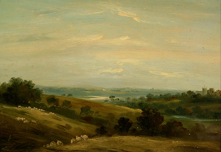
A 19th century oil painting looking at rolling hills in Martlesham towards the River Deben

Martlesham by George James Rowe.  Courtesy of Colchester + Ipswich Museums, Ipswich Borough Council Collection.

Old Martlesham had become a thriving centre of trade, virtually self-sufficient. The coaching inn, now called the Red Lion, was on the regular route of drovers of cattle and sheep on their way to Smithfield market in London. The surrounding countryside, farmlands and Creek were a favoured subject of landscape paintings by the 'Woodbridge circle' of painters which included Thomas Churchyard and George James Rowe.

The Bantoft family

In the 1860s, Martlesham Wilds was united under one landowner - the eccentric "Colonel" George Tomline whose Suffolk seat was Orwell Park. Tomline spent much of his time and immense wealth buying up land between Ipswich and Felixstowe and eventually became the second largest landowner in Suffolk. He was famous for the development of the railway to Felixstowe and the early development of the port. He was also legendary for his legal disputes and was known as 'a dangerous man to quarrel with, with the will and power to be a very nasty enemy in every sense of the word'.

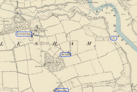
An 1881 OS Map of Martlesham

Extract from OS map Suffolk LXXVI.NE 1881. Reproduced with the permission of the National Library of Scotland.

Hill Farm is named in the 1881 OS map. The census of the same year places 50 year old Charles Bantoft as farmer of 750 acres, employing fourteen men and five boys, and living with his wife Eliza first at Howes Farm and then at Bantoft's Farm. His son, also called Charles, farmed a further 738 acres, employing eight men and two boys and living at the Hall with a groom and gardener. So it appears that father and son between them were farming all of the Wilds.

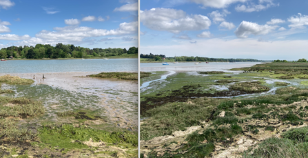
A landing point or pier going out into the Deben, with a track leading across the saltings to what is now called Dock Field, can still be seen at low tide. It is thought that this cutting, known as Bantoft's Dock, was made by the farmer at Hill Farm to take the farm produce up and down river.

Photos looking out to landing points on the River Deben at Martlesham Wilds

Landing point and Bantoft's Dock. Photographs by Margaret King.


By the end of the century, Suffolk was hit by an agricultural depression.  The Bantofts - father and son - moved to Norfolk with their families. Tomline died and the estate was inherited by Ernest Pretyman who installed a farm bailiff and gamekeeper at the Hall to manage both Hall and Hill Farms.

Twentieth century

A damaged WW2 bomber returning home in the 1940s jettisoned its bombs over empty countryside before landing and hit the river wall near Cross Farm, flooding the land of Martlesham Wilds through a 40 metre gap right up to the Creek.  This is just one of the times that the land was flooded.

Hall Farm had become a dairy farm and Hill Farm an arable farm. Pretyman sold them both in 1945, with the exception of the Hall itself and of the shooting rights on Lumber Wood (which Pretyman kept for the next five years). Ten years later the two farms, known simply as Hill Farm, were acquired by RAF Group Captain Edward P Wells, a famous flying ace for the Royal New Zealand Air Force. Wells later moved to Spain and John Symes inherited Hill Farm in 1963 from his father.

And the rest, as they say, is history - the farm was sold in two lots in 2022, with the bulk of the land going to the Suffolk Wildlife Trust for the creation of Martlesham Wilds nature reserve.